For community administrators

See the risk. Share the location. Coordinate the response.

Give your organisation the tools to review fire reports, keep members informed and coordinate incidents. Bring locations, updates and local water resources together, with access controlled by your administrators.
Relevant device alertsGPS fire reportingShared incident locations
Community Firenow
Fire confirmed in your areaTap to view the incident location and latest status.
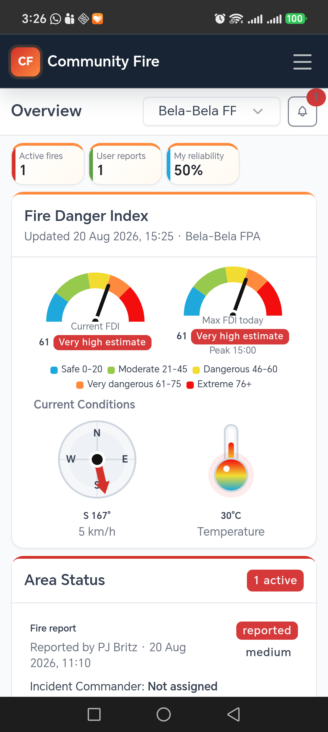
Community Fire mobile app showing the Bela-Bela FPA overview, fire danger and current conditions

Community Fire works for FPAs, estates, reserves, conservancies, farm groups and independent rural communities. FPA membership is not required to use the core platform.

The alert comes to youNo need to watch a dashboard all day.
Everyone sees the same locationOpen the incident, map and response details.
Local people add contextReports are attributable and admin reviewed.
Push notifications

Keep the right people informed.

Relevant fire information can reach people on the device they already carry, whether they are working on a farm, travelling, or away from a command-centre screen.

Community and boundary targeted
Administrators choose recipients and urgency for supported incident events, including new reports, confirmation, assistance required, under control and put out.
Tap back into the incident
A fire notification carries the report reference so the app can open the relevant incident information.
FIRMS is an admin aid, not an automatic public alarm
Satellite hotspots remain visually separate. An administrator can review and convert a relevant detection into a local fire incident before wider incident alerts are used.
Example alert flow
Community Fire · now

Kariba Fire - Assistance required

Assistance has been requested for an active fire in your community. Tap to view the location and incident details.

The wording and recipients depend on the community's configured alert rules and the incident event.

Your incident workflow

From the first report to a recorded outcome.

Give your administrators a consistent way to review reports, share updates and maintain a record, while members contribute from their phones.

1

Report or detect

Members select a location, add observations and attach optional photos or video. FIRMS supplies separate satellite detections for admin review.

2

Verify

Review the evidence and location, then confirm, reject or mark the report as already reported.

3

Notify

Choose which supported events alert admins, boundary members, the reporter or the assigned commander.

4

Coordinate

Assign an Incident Commander, update status and share the incident location. Members can open navigation and nearby water points.

5

Keep the record

Record comments and status changes through to put out. Administrators retain the timestamped incident history.

See the workflow

From a field report to an organised response.

Short visual walkthroughs show how a report reaches the map and how an administrator keeps the incident current.

Administrator

Manage the incident

See the incident controls your administrators use to review information and keep the operational record current.

Community member

Report a fire

See how a member supplies the location and observations your administrators need, using the Android app.

Recorded in Community Fire using demonstration data. Silent videos; use the playback controls to pause.
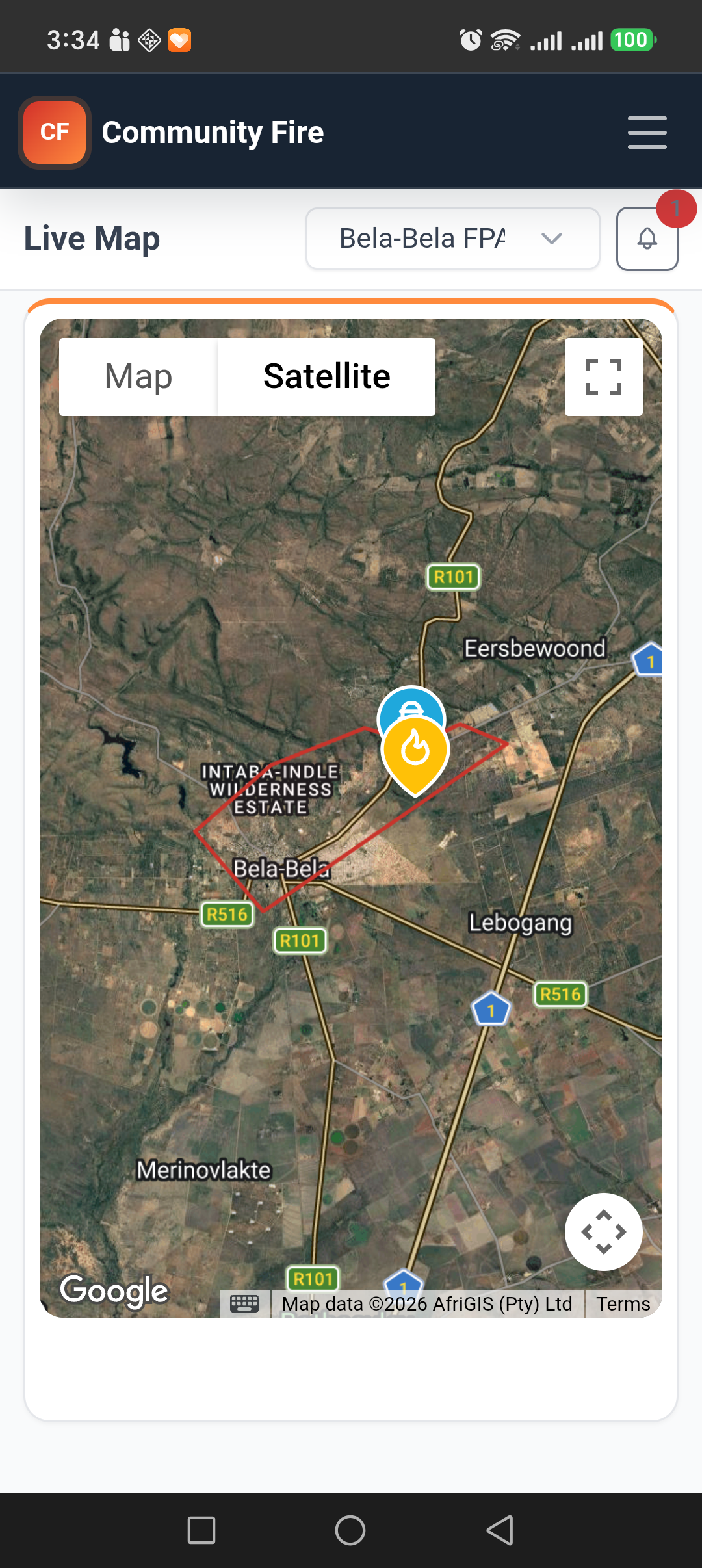
Community Fire mobile live map showing the Bela-Bela FPA boundary, active fire and water point
Mobile fire reporting

Make local reports useful to your administrators.

A community member can create a report from an accurate device location or choose the position directly on the map. The report goes into the correct boundary for administrator review.
Wait for an accurate locationThe app shows location progress and uses the best available GPS result before opening the report form.
Choose a map positionLong-press the live map and report the fire at the selected point.
Add useful contextSupply severity, a short fire description and optional consented photo or short video evidence.
Admin reviewedAdministrators can confirm, mark as already reported, reject, rename or correct the pin position.
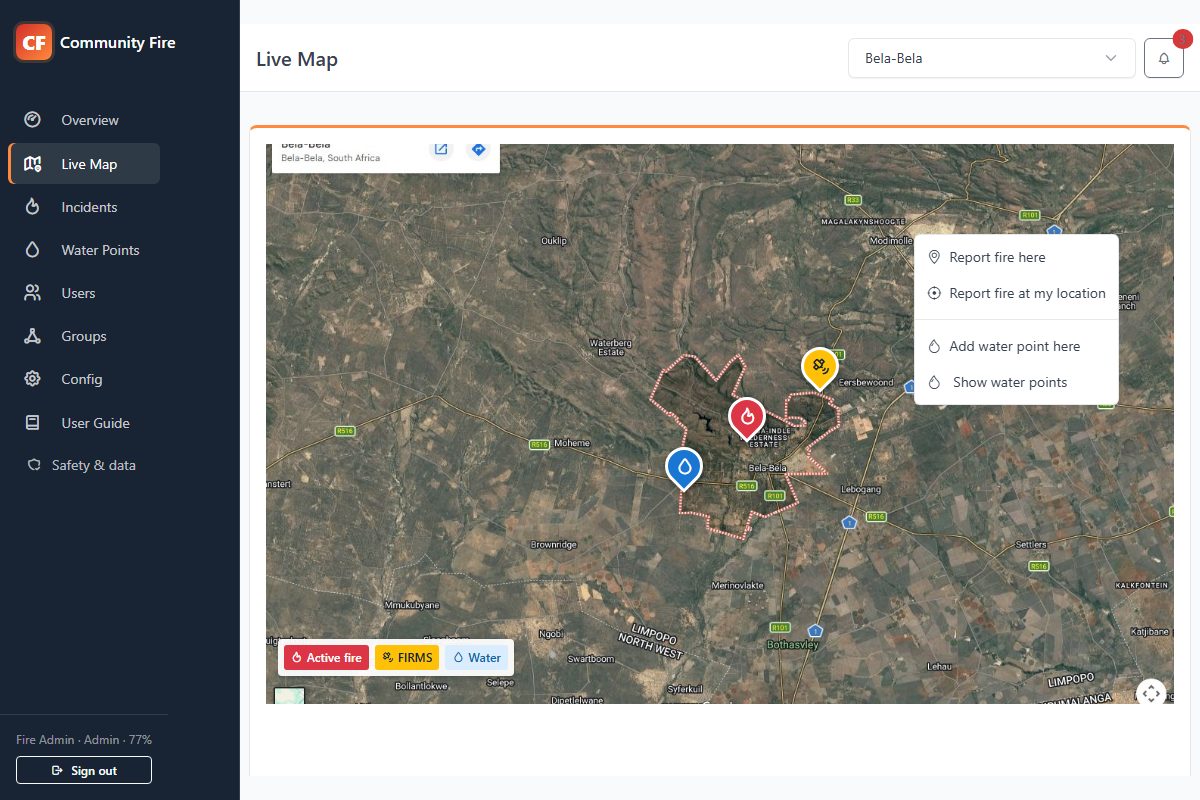
Community Fire live map showing the Bela-Bela boundary, fire reports, FIRMS detections and water points
Live operational map

A shared picture of the fire situation

Every boundary group gets a focused map where local reports, satellite detections and response resources can be understood without mixing in irrelevant areas.

Active fires are immediately recognisableFire pins use distinct icons and colours for severity and operational state. Put-out, rejected and duplicate reports leave the live view while remaining available in incident records.
FIRMS detections stay clearly separateNASA FIRMS hotspots use their own satellite marker. They do not count as active fires until an administrator reviews the detection and converts it into a confirmed local incident.
Report the right positionUsers can long-press the map or wait for an accurate device location. The report form captures severity and a short description, while administrators can correct the pin later.
Move from information to actionOpen a fire in the device's navigation app, share its location, jump directly to its incident record or inspect the full timestamped report details.
Boundary focusedUsers see the groups linked to them and keep their last selected group.
Fullscreen readyUse Google Maps fullscreen while long-press actions continue to work on mobile.
Shareable locationsSend a usable location link to teams who are not registered in the app.
Automatically refreshedFIRMS, weather and fire state update without relying on a manual refresh button.
Linked fire spreads

Keep the changing fire picture connected.

Mark observed spread locations and keep each one linked to its origin fire. Your administrators can coordinate individual fronts while retaining the wider incident record.

Mark and adjust observed spread

Add multiple spread pins from an active origin fire, then drag each pin to the observed location. Position changes save automatically.

Manage each spread as an incident

Set its severity and status, assign an Incident Commander, add comments and review its history. Open the origin or a linked spread from the same incident record.

Notify the relevant people

Configure a fire-spread-added alert for administrators, boundary members and the origin incident's commander. Members see active spreads only in areas they are authorised to access.

Spread pins record observations entered by administrators. They do not predict fire movement or establish a safe route. Device alerts depend on permissions and connectivity.

See spread tracking in a demo
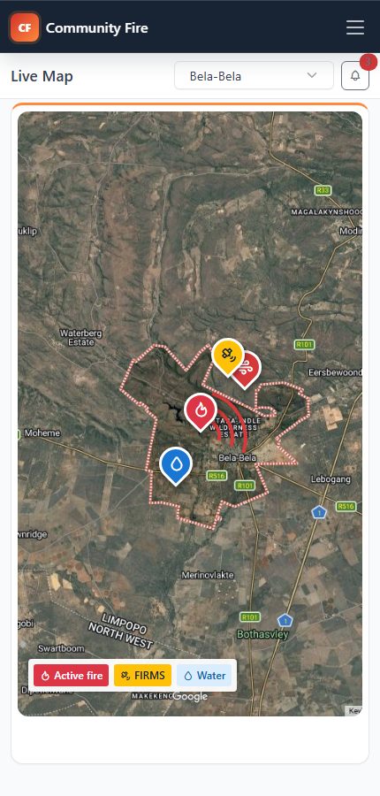
Community Fire demonstration showing observed fire spreads linked to an origin incident

Observed spread in the administrator map workflow, using demonstration data.

Feature preview — testing in progress. Incident access gates are being evaluated before wider release. Ask to see the workflow in a guided demo.
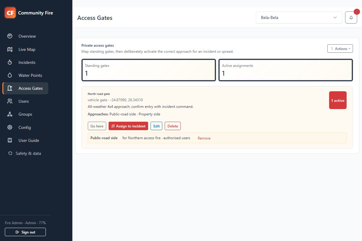
Community Fire administrator Access Gates page showing a private gate linked to an active fire incident
Incident access gates · Preview

Guide responders to the right side of the fire

Administrators map private standing gates, define both sides of the fence, and activate the correct approach for a specific fire or spread when it is needed.
Map or GPS captureAdd a gate directly on the map or from the administrator's current accurate device location, then edit or drag it as the property picture changes.
Choose the approach sideName the inside and outside approaches, link the gate to the exact origin fire or spread, and navigate to the approved approach point instead of simply choosing the nearest gate.
Private until activatedEnd users cannot browse the standing-gate directory. They receive only an explicitly shared approach for an active incident they are already authorised to view.
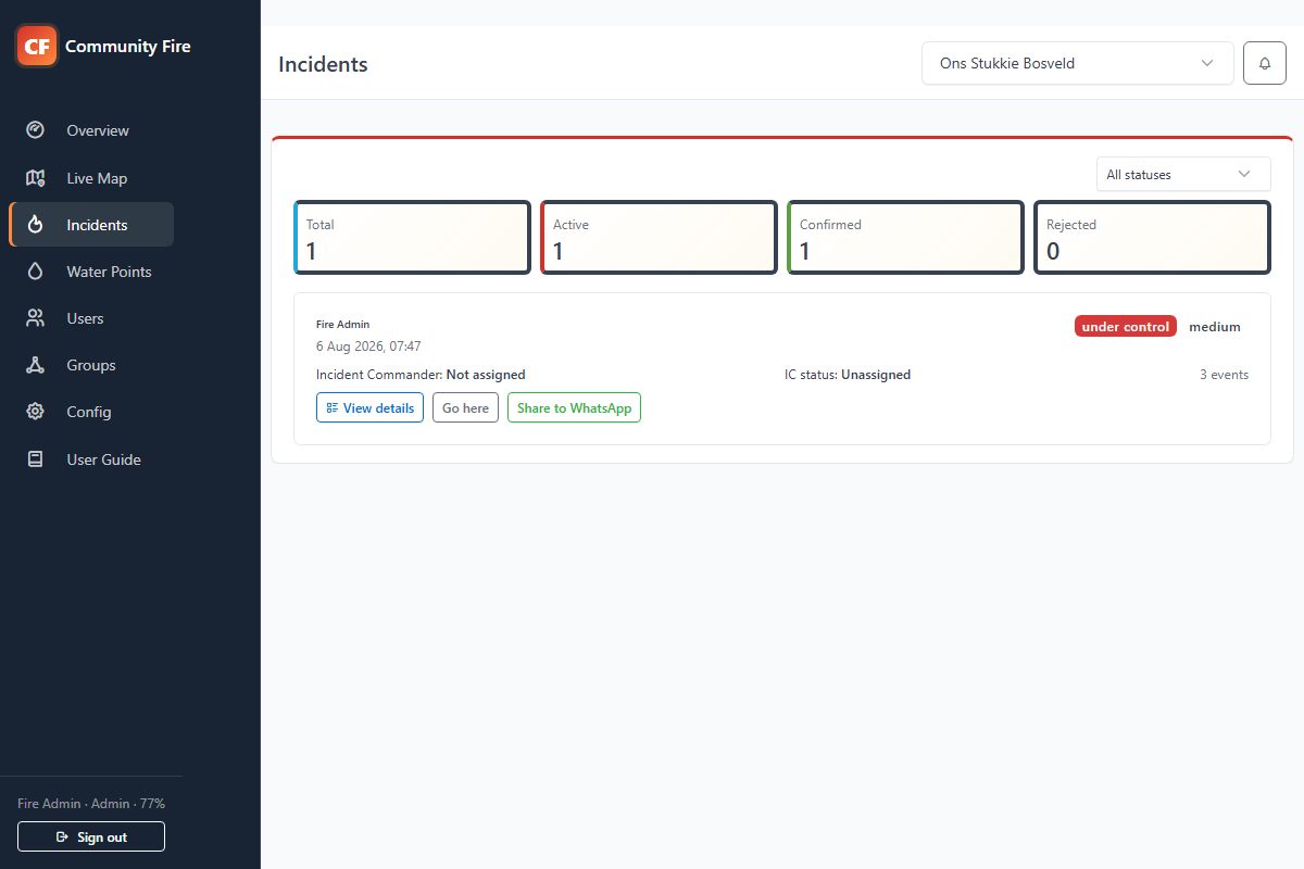
Community Fire incident management screen
From report to resolution

One incident record everyone can understand

Reports remain easy to navigate while the complete event trail is available when administrators need the detail.

Reliability scoringBuilt from admin confirmations without penalising duplicate reports.
Location firstOpen navigation, share coordinates and move pins when an admin confirms a better position.
Status alertsAssistance required, under control, put out and other operational states.
Role basedEnd users see their community while administrators manage the response.
Water-point directory

Know where usable water is before it is urgent

Build a shared, maintained directory of firefighting water sources and reveal them on the live map when an active fire is close enough to matter.
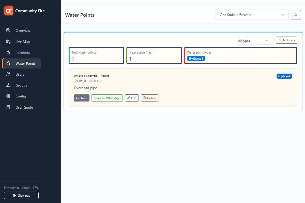
Typed resourcesClassify dams, hydrants, tanks, pools, boreholes and other sources, then filter the directory by type.
Operational notesRecord access instructions, capacity, pump fittings, contact details or restrictions responders need to know.
Community maintainedEnd users can add and manage their own water points. Administrators can verify and manage every point in the group.
Relevant when neededA configurable radius limits automatic map visibility to water points near an active fire, keeping the live view readable.
Community Fire water-point management page with resource totals, types and actions
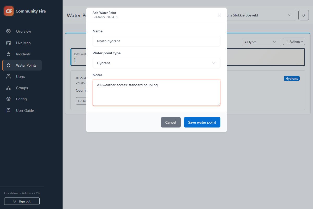
Community Fire form for naming and describing a water point

Add one from where you stand or directly on the map

A user can add a water point at their current GPS location, while the map action allows a precise point to be selected elsewhere. Give it a useful name, choose its type and add the notes responders will need.

Open in navigationShare the locationShow all on map
Tools for your team

Control for administrators. Simple participation for members.

Choose a subscription for your organisation, then give members access to the areas they need. Administrators manage verification, incident updates and participation; members report observations and follow authorised active incidents.

Administrators and coordinators

The wider operational picture

Review distinct FIRMS detections
Confirm or classify reports
Assign Incident Commanders
Configure alert recipients
Manage boundaries and access
Keep timestamped incident history
Landowners, residents and responders

Relevant fire information on your phone

Receive configured push alerts
Report a fire by GPS or map pin
View active fires and status
Open locations in navigation
Find and maintain water points
Add consented incident evidence
Compare the capabilities

What your community gets

A practical feature list for the people choosing and running the subscription. Packages set capacity; roles determine what each person can do.

Community app capabilities by role. Access depends on assigned boundaries, community settings and device permissions.
CapabilityYour administratorsYour members
Fire reportingReview location, severity, notes and consented evidence; correct an incident pin.Report by GPS or map position and attach an optional photo or short video.
Report verificationConfirm, reject or mark duplicate reports before wider operational use.Follow confirmed active incidents in authorised boundaries.
Incident coordinationName incidents, change severity, assign an Incident Commander and update command status.See the current incident information and assigned commander.
Fire spread trackingAdd and move linked spread pins; manage each spread’s severity, commander, status and history. Configure alerts when a spread is added.View authorised active spreads and open their incident details from configured alerts.
Status and recordsSet assistance required, under control or put out; add comments and review timestamped history.Follow authorised active incident updates. Historical incident records remain admin-only.
Targeted alertsChoose recipients and urgency for supported incident events.Enable device notifications and open the associated incident when authorised.
Satellite detectionsReview distinct NASA FIRMS hotspots and report relevant detections as local incidents.Receive authorised incident information after review; raw FIRMS pins are admin-only.
Shared map and navigationView boundary context and permitted incident locations; correct recorded positions.Open active incident locations in navigation or share a location through WhatsApp.
Water pointsMaintain the group directory, filter resource types and set the nearby-fire display radius.Add and maintain own points; see permitted water points near active fires.
Weather and estimated FDIReview current conditions, wind and local estimated fire-danger information.View conditions for the selected authorised boundary. Estimates are advisory.
Boundaries and accessDraw operating areas, receive admin-only alerts for new joining requests, approve access and assign members to boundary groups.Join using a community code and request access to additional areas.
User managementManage roles, active accounts and Incident Commander eligibility.Use the functions and boundaries assigned to the account.
Community noticesPublish, schedule, edit or disable notices for signed-in members.Read community notices and pause or dismiss the rotating banner.
Community supportSet local support contacts and submit platform support requests.Find the community support information and role-specific user guide.

Device alerts depend on connectivity, notification permissions and operating-system controls. Android and iOS are in testing; ask about current device availability when booking your demo. Access gates are a preview and are not included as a released capability in this table.

Launch special

Choose the reach your community needs

Every package includes the complete operational app and unlimited end users. Launch-special pricing is available to new communities while Community Fire establishes its first customer group.

Loading current packages...

The operational features are included in every package

Packages change community capacity, not the core fire-response workflow.

Mobile app and push
Device alerts, incident opening, GPS reports and mobile response information.
Live operational map
Fire reports, distinct FIRMS detections, severity pins, boundaries and navigation.
Incident coordination
Confirmation, Incident Commanders, statuses, comments and timestamped history.
Water points
Typed resources, access notes, GPS capture, map display and location sharing.
Fire conditions
Weather, wind and estimated current and maximum Fire Danger Index.
Community access
Admin and end-user roles, access requests, group assignment and reliability scoring.
Isolated deployment
A dedicated community domain and separate operational database.
Support route
Community first-line support with platform escalation and service status.
Larger than the Regional package?
FPAs, umbrella organisations and multi-community deployments can request a tailored capacity and support quotation. Core operational features remain available regardless of FPA membership.

Choose how you subscribe

The package controls capacity. The billing option controls when and how you pay.

Available

Monthly

Pay month to month while keeping the community active continuously.

  • Lowest initial commitment
  • Continuous access and alerts
  • Recurring monthly payment
Best year-round value

Annual

Pay once for twelve months of continuous operation at the discounted annual price shown above.

  • Two months effectively discounted
  • Continuous access and alerts
  • One recurring annual payment
Seasonal pilot

Seasonal

Choose 3-8 consecutive active months, including a season that crosses into the next year.

  • Full operation during selected months
  • Data, users, domain and history retained off-season
  • Off-season app becomes read-only while external refreshes and alerts pause
  • Season price confirmed from the package and selected months
Register seasonal interest
Seasonal subscriptions are currently a pilot option. We will confirm the selected months, price and activation date before any payment is requested.

From application to a working community

A reviewed setup keeps boundaries, administrators and billing accurate from the beginning.

1

Apply

Tell us where your community operates, roughly how many people will participate, and which package fits.

2

Confirm

We contact you to confirm administrators, boundaries, billing and the people responsible for first-line support.

3

Launch

Your community receives its own secure domain, community code and guided setup before end users join.

Questions

What the app does today

Clear answers about alerts, FIRMS, reporting and community access.

Request a guided demo

No. Once notifications are enabled and the device is registered, the native app can receive Firebase push notifications while it is in the background or closed. Delivery still depends on the device's notification settings, connectivity and operating-system controls.

No. FIRMS detections are shown separately to administrators as possible hotspots. They do not count as active local fires until an administrator reviews and converts a relevant detection into an incident.

Yes. Use an accurate current location or long-press the live map to choose the fire position, then add severity, a short description and optional consented evidence before submitting it to the community.

Incident notifications include the related report reference. Tapping the alert launches Community Fire and routes the signed-in user to the relevant incident information.

Community administrators configure each supported alert rule. Depending on the event, recipients can include administrators, users linked to the boundary group, the original reporter and the assigned Incident Commander.

No. The core platform works for independent organisations and communities. An FPA can use Community Fire as its own community platform, and future approved integrations can add coordination without making FPA membership a requirement.
Community application

Start the conversation

Submitting this form does not create a paid subscription. We will review the area and contact you to confirm the next steps.

Your operational data will live in an isolated community deployment.
Community administrators become the first support contact for their users.

Tell us about your community

Just enough detail for us to contact you and understand the likely fit.